
Status for: Burned Area (MCD64)
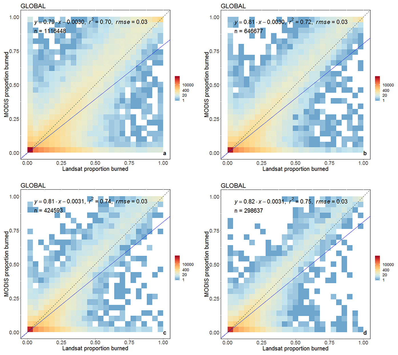
Scatter plot of the proportions of coarse resolution 5 km × 5 km cells labeled as burned by the
MCD64A1 product, plotted against the proportion labeled as burned by the Landsat 8
independent reference dataset, combining the voxel results globally. The point density
distribution is calculated using a 25 × 25 quantization of the plot axes, and is displayed with
a logarithmic color scale. The blue lines show the ordinary least squares regression of the
proportion data; the dashed 1:1 line is shown as reference.
Click on the graphic to see a larger version.
Stage 3 validation has been achieved for the MODIS Collection 6 burned area product.
The validation of the areal estimates of the MODIS burned area product relies mainly on the use of high-resolution Landsat scenes. Stage 1 validation was achieved parallel to the development of the product with a number of validation sites in Africa, Australia, Brazil, Siberia and the United States. Stage 2 validation of the Level 3 combined Aqua-Terra burned area product was achieved with the Collection 5.1 datasets and Stage 3 was achieved with the Collection 6 dataset.
The latest version (Collection 6) of the MODIS Global Burned Area Product was released in 2017. The new product (MCD64) supersedes the heritage Collection 5.1 (C5.1) MCD64A1 and MCD45A1 products which have been deprecated. The new algorithm is designed to be extremely tolerant of cloud and aerosol contamination, which affected the Collection 5.1 MCD45 product. As a consequence, the Collection 6 MCD64 product has significantly better detection of small burns, a modest reduction in burn-date temporal uncertainty, and a large reduction in the extent of unmapped areas compared to the C5.1 product. Among other applications, this product was used create the very widely used higher-level Global Fire Emissions Database.
The algorithm applies dynamic thresholds to composite MODIS Terra and Aqua imagery generated from a burn-sensitive spectral band index derived from MODIS 1240 nm and 2130 nm Terra and Aqua bands, and a measure of temporal variability. Cumulative MODIS 1 km active fire detections are used to guide the selection of burned and unburned training samples and to guide the specification of prior burned and unburned probabilities. The MCD64A1 product is distributed in the standard MODIS Level 3 land 10° × 10° tile format in the sinusoidal projection.
The product is validated at Stage 3 by comparison with Landsat 8 Operational Land Imager (OLI) image pairs acquired 16 days apart that were visually interpreted. These independent reference data were selected using a stratified random sampling approach that allows for probability sampling of Landsat data in both time and in space. A total of 558 Landsat 8 OLI image pairs (1116 images), acquired between March 1, 2014 and March 19, 2015 were selected. Globally, the MCD64A1 product had an estimated 40.2% commission error and 72.6% omission error; the prevalence of omission errors is reflected by a negative estimated bias of the mapped global area burned relative to the Landsat independent reference data (-54.1%). Globally, the standard errors of the accuracy metrics were less than 6%. The product accuracy was also characterized at coarser scale using metrics derived from the regression between the proportion of coarse resolution grid cells detected as burned by MCD64A1 and the proportion mapped in the Landsat 8 interpreted maps. The errors of omission and commission observed at 30 m resolution compensate to a considerable extent at coarser resolution, as indicated by the coefficient of determination (r2 > 0.70), slope (> 0.79) and intercept (-0.0030) of the regression between the MCD64A1 product and the Landsat independent reference data in 3 km, 4 km, 5 km and 6 km coarse resolution cells. The analysis of the deviations between the proportion of area burned mapped by the MCD64A1 product and by the independent reference data, performed using 3 km x 3 km and 6 km x 6 km coarse resolution cells, indicates that the large negative bias in global area burned is primarily due to the systematic underestimation of smaller burned areas in the MCD64A1 product.
Product version: Collection 6.1
| Title: Global validation of the Collection 6 MODIS burned area product |
| Author: Boschetti, L, Roy, D.P, Giglio, L., Huang, H, Zubkova, M, and Humber, M. |
| Source: Remote Sensing of Environment, 235, 111490 |
| View Abstract and Access Publication |
| Title: Spatial and temporal intercomparison of four global burned area products |
| Author: Michael L. Humber and Luigi Boschetti and Louis Giglio and Christopher O. Justice |
| Source: International Journal of Digital Earth |
| View Abstract and Access Publication |
| Title: The collection 6 MODIS active fire detection algorithm and fire products |
| Author: Louis Giglio, Wilfrid Schroeder, Christopher O. Justice |
| Source: Remote Sensing of Environment, Volume 178, 2016, Pages 31-41. |
| View Abstract and Access Publication |
| Title: A stratified random sampling design in space and time for regional to global scale burned area product validation |
| Author: Boschetti, L., Stehman, S. V., & Roy, D. P. |
| Source: Remote sensing of environment, 186, 465-478 |
| View Abstract and Access Publication |
| Title: Global assessment of the temporal reporting accuracy and precision of the MODIS burned area product |
| Author: Boschetti L., Roy, D., Justice, C. and Giglio, L. |
| Source: International Journal of Wildland Fire, 19(6), pp.705-709, 2010 |
| View Abstract and Access Publication |
| Title: Southern Africa Validation of the MODIS, L3JRC and GlobCarbon Burned Area Products |
| Author: David Roy and Luigi Boschetti |
| Source: IEEE Transactions on Geoscience and Remote Sensing, ol. 47(4), pp. 1032 - 1044, doi:10.1109/TGRS.2008.2009000 |
| View Abstract and Access Publication |
| Title: The collection 5 MODIS burned area product - Global evaluation by comparison with the MODIS active fire product |
| Author: D.P. Roy, L. Boschetti, C.O. Justice, J. Ju |
| Source: Remote Sensing of the Environment, 112 (2008), 3690-3707 |
| View Abstract and Access Publication |
| Title: Prototyping a global algorithm for systematic fire-affected area mapping using MODIS time series data |
| Author: Roy, D.P., Jin, Y., Lewis, P.E., Justice, C.O. |
| Source: Remote Sensing of Environment, Volume 97, Issue 2, 30 July 2005, Pages 137-162 |
| View Abstract and Access Publication |
