
Multi-Angle Implementation of Atmospheric Correction (MAIAC) (MCD19)
MAIAC is a new advanced algorithm which uses time series (TMS) analysis and a combination of pixel- and image-based processing to improve accuracy of cloud detection, aerosol retrievals and atmospheric correction (Lyapustin et al., 2011a,b; 2012; 2018). TMS focuses on extensive characterization of the surface background in order to improve all stages of MAIAC processing. MAIAC starts by gridding MODIS L1B data to a fixed grid at 1km resolution (using area-weighted method, Wolfe et al., 1998) in order to observe the same grid cell over time and work with polar-orbiting observations as if they were geostationary.
To enable the time series analysis, MAIAC implements the sliding window technique by storing from 4 (at poles) to 16 (at equator) days of past observations in operational memory. This helps to retrieve surface BRDF from accumulated multi-angle set of observations, and detect both seasonal (slow) and rapid surface changes. A detailed knowledge of the previous surface state also helps MAIAC's internal dynamic land-water-snow classification, including snow detection and characterization.
Consistent with Collection 6 (C6) MODIS land processing, the top-of-atmosphere (TOA) L1B reflectance includes standard C6 calibration (Toller et al., 2014), augmented with polarization correction for MODIS Terra (Meister et al., 2012), residual de-trending and MODIS Terra-to-Aqua cross-calibration (Lyapustin et.al, 2014). Due to cross-calibration, MAIAC processes MODIS Terra and Aqua jointly.
MAIAC provides a suite of atmospheric and surface products in HDF4 format, including: (1) daily MCD19A1 (spectral BRF, or surface reflectance), (2) daily MCD19A2 (atmospheric properties), and (3) 8-day MCD19A3 (spectral BRDF/albedo).
The MAIAC product layers over land include :
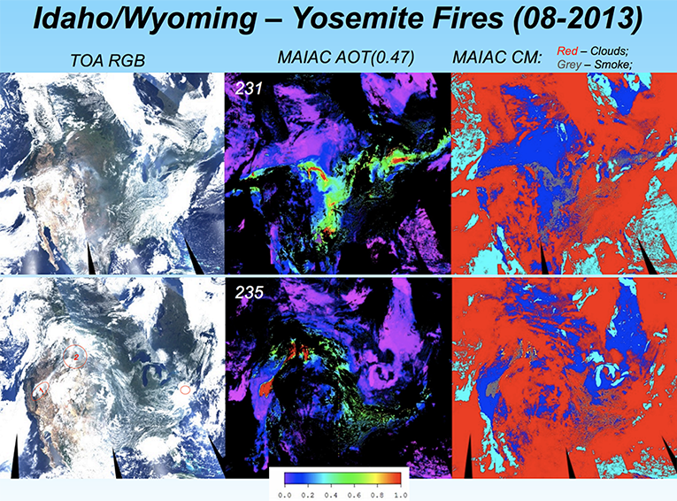
- Daily Atmosphere (MCD19A2), at 1km: column water vapor (CWV), cloud mask, aerosol optical depth (AOD) and aerosol type (background/smoke/dust), smoke injection height;
- Daily Land Surface (MCD19A1), spectral BRF at 1km (bands B1-B12) and at 500m (B1-B7): snow grain size, and sub-pixel snow fraction at 1km for detected snow
- 8-day Land Surface (MCD19A3), at 1km in bands B1-B7): BRDF (RTLS model, naturally gap-filled using previous retrievals for a given grid cell) and instantaneous albedo
Over inland, coastal and open ocean waters, MAIAC reports CWV (over clouds), AOD, fine mode fraction, and spectral reflectance of underlight (or equivalent reflectance of water-leaving radiance) at 1km resolution in bands B1-B12.
Product PI: Alexei Lyapustin
User Guide - C61
ATBD
See links below to the Product Description pages posted at the LP DAAC (product details, data access links, and more....)
Product NameLand Surface BRF Daily L2G Global 500m and 1km SIN Grid Land Aerosol Optical Thickness Daily L2G Global 1km SIN Grid BRDF Model Parameters 8-Day L3 Global 1km SIN Grid |
Combined Aqua & Terra Product ID |
|
