
Water Reservoir
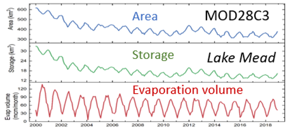
The MODIS Water Reservoir product includes time series of surface area, elevation, storage, evaporation rate, and volumetric evaporation. The MOD28 reservoir surface area algorithm is based on image classifications of NIR reflectance from both Terra (MOD09Q1) and Aqua (MYD09Q1). The storage and elevation values are calculated by applying the area to the pre-established Area-Volume-Elevation (AVE) curves for each reservoir of interest. The MOD28 reservoir evaporation rate is estimated using the newly developed Lake Temperature and Evaporation Model (LTEM). In the LTEM the MODIS LST data (MOD11A2 and MYD11A2) are employed to constrain the modified Hostetler Model for calculating lake water temperature profiles. The temperature profiles were then used to calculate lake heat storage change term in the Penman equation. The calculation of the evaporation rate also requires gridded meteorological inputs from GLDAS and bathymetric data. The volumetric evaporation is calculated as the product of the evaporation rate and surface area.
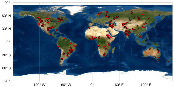
This product provides data for 164 global reservoirs. It includes 151 man-made reservoirs (2,672 km3) and 13 regulated natural lakes (23,801 km3). The total storage capacity of the 151 man-made reservoirs represents 45.82% of the global capacity (in its category) according to the Global Reservoir and Dam Database (GRanD). The MOD28 product is available as both an 8-day and a monthly temporal resolution, however, the evaporation rate and volumetric evaporation parameters are only available in the monthly product. All of these estimates are made available in tabular form, using the VDATA model in HDF format.
In order to enhance the utility and accessibility for a wider user base, an interactive website has been created to help users easily generate plots and download reservoir-specific time series from the MODIS Water Reservoir product.
These MODIS reservoir observations can be used to support various applications, such as hydrological monitoring and modeling, water resources management, and Earth system modeling.
Product PI: Huilin Gao
User Guide - C7
ATBD
See links below to the Product Description pages posted at the LP DAAC
(product details, data access links, and more....)
In addition, the reservoir-specific time series can also be downloaded from this interactive website.
Product NameArea, elevation, and storage 8-day Area, elevation, storage, evaporation rate, volumetric evaporation monthly |
Terra Product ID |
Aqua Product ID |
References
Zhao, G., X. Cai, and H. Gao, Estimating lake temperature profile and evaporation losses by leveraging MODIS LST data, Remote Sensing of Environment (2020), https://doi.org/10.1016/j.rse.2020.112104, 2020.
Li, Y., Zhao, G., Shah, D., Zhao, M., Sarkar, S., Devadiga, S., Zhao, B., Zhang, S., and Gao, H. (2021). NASA's MODIS/VIIRS Global Water Reservoir Product suite from moderate resolution remote sensing data. Remote Sensing, 13(4), 565; https://doi.org/10.3390/rs13040565.
